InSAR
Satellite-based InSAR for Ground Movement Monitoring.
What Is InSAR? Ground Movement Detection with Satellite Precision
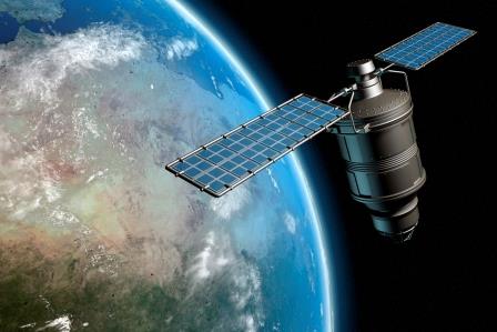
Conventional ground movement monitoring relies on specialist equipment and expert surveyors, with varying precision and limited coverage. These methods are slow and resource-intensive. In contrast, satellite-based InSAR offers remote, high-density measurements with millimetric accuracy across wide areas. It enables long-term monitoring by comparing historical data with new observations captured every 6–12 days. While InSAR is now an established method, its processed results can be difficult for non-experts to interpret without accessible analytics and visualization tools.

Actionable Insights, Enhanced Safety & Planning
Rezatec delivers easy-to-use InSAR analytics through an operational platform, tailored to your organization. It is used by organizations across the world to overcome inspection gaps, reduce monitoring costs, intelligent deployment of sensors and make smarter decisions around planning, compliance, and risk.
Reduce operational costs
InSAR (Interferometric Synthetic Aperture Radar) reduces operational costs by enabling remote, high-precision monitoring of infrastructure. It detects millimetric ground or structural shifts, helping identify issues early and prevent costly failures. Cities like Essen have cut monitoring costs by up to 40% using InSAR. Its wide-area coverage and accuracy make it ideal for proactive maintenance of critical assets like bridges, railways, and pipelines.
Assess Risk & Protect Public Safety
InSAR strengthens risk management and public safety by detecting early signs of ground movement and structural stress, allowing for timely, preventive action. Its high-resolution, wide-area monitoring supports data-driven decisions that reduce the risk of accidents, service disruption, or costly failures. Especially valuable in sectors like transport, energy, and infrastructure, InSAR helps prioritize maintenance and protect communities—enhancing resilience and safety in high-risk or densely populated areas.
Better urban and environmental planning
InSAR is a powerful tool for urban and environmental planning, enabling continuous monitoring of land deformation caused by factors like groundwater extraction, construction, or natural subsidence. It provides planners and policymakers with accurate, long-term data on ground movement across entire cities or regions, helping identify areas at risk before visible damage occurs. This insight supports smarter zoning decisions, safer infrastructure development, and more sustainable land use. In environmental contexts, InSAR can track the impact of climate change on ecosystems, monitor wetlands, and assess land degradation—informing proactive conservation and resilience strategies.
Key Advantages of Our Solution
Comprehensive Surface Deformation Intelligence
Rezatec’s InSAR monitoring solution complements your current monitoring practices by delivering precise, high-resolution ground movement insights. This cost-effective approach streamlines data interpretation, providing historical and continuous analysis at significantly lower costs compared to conventional methods. Free your engineering teams from labor-intensive data management tasks, allowing them to focus on critical decision-making, supported by our intuitive analytics platform.
Early detection
Early detection of surface movement that may indicate structural issues or subsurface instability
Wide-area, high-resolution coverage
Wide-area, high-resolution coverage that complements ground-based sensors at a lower cost
Historical insight
Historical insight, using archived satellite data to reveal trends predating recent inspections
Millimeter-scale accuracy
Millimeter-scale accuracy, enabling detection of movements well before they are visible or measurable by traditional methods
Proven & Trusted
Rezatec’s method for InSAR processing has been validated against GNSS and GPS data demonstrating consistently accurate results. InSAR-based ground deformation monitoring uses radar satellite imagery to detect and measure subtle movements of the Earth’s surface over time. This is achieved by analysing the phase difference between multiple radar images taken from the same location in space at different times. By carefully selecting persistent and distributed reflectors, the technique isolates true ground motion from atmospheric noise and other distortions, enabling millimeter-level accuracy. The result is a time series of vertical displacements across a wide area, making it a powerful tool for identifying long-term trends or sudden shifts in ground stability.
Rezatec Geospatial Platform
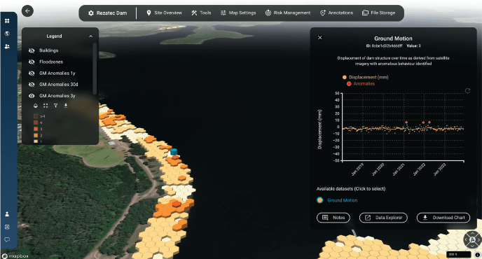
Quick to sign up, and easy to add your data, our platform gives you 24/7 secure access to your data from anywhere. The platform features advanced visualisations that allow you to map, analyse, and interpret your insights with ease. Powerful interactive tools enable you to explore, filter, and interrogate your data, helping you make informed decisions with greater accuracy and confidence.
- Record notes geospatially
- Notify and share across colleagues
- Compare data geospatially and temporally
- Integrate seismic, weather and wild-fire alerts
- And more…

Explore Our Insights on Geospatial Analytics

Speak to us today
Our team is here to answer your questions. We’re excited to help you explore how geospatial analytics can support your business. Just fill out the form and we’ll get back to you.


